Study OAS Prism
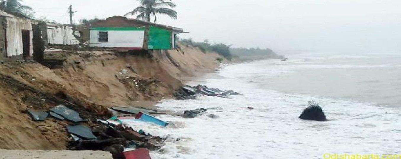
On the floor of the Rajya Sabha in August 2026, Union Minister Sarbananda Sonowal disclosed a figure that should alarm every coastal administrator and policy aspirant: 28.3 per cent of Odisha’s 564.14-km coastline is currently under active erosion. The statement came in response to a pointed question by BJD MP, and it drew upon a systematic shoreline assessment conducted by the National Centre for Coastal Research (NCCR) spanning three decades — 1990 to 2022.
What makes this disclosure significant is not merely the percentage, but what lies behind it: vanishing villages, displaced fishing families, collapsing agricultural land, and a biodiversity crisis unfolding silently along India’s eastern coast. Odisha’s shoreline is not losing ground because of one cyclone or one bad season. It is losing ground because of a structural failure of governance, an acceleration of climate change, and decades of inadequate coastal management.
Odisha’s Coastal Geography —
Odisha’s 564 km coastline stretches across six coastal districts — Baleshwar, Bhadrak, Kendrapara, Jagatsinghpur, Puri, and Ganjam — all abutting the Bay of Bengal. It is not merely a geographical strip; it is the economic and ecological backbone of millions of lives.
The coastline hosts the Port of Paradip (India’s major eastern gateway), the deep-water Dhamra Port, and the Gopalpur Port — all pivotal to Odisha’s industrial future. It shelters Bhitarkanika National Park (India’s second-largest mangrove ecosystem, 212+ sq km), Gahirmatha Marine Sanctuary (the world’s largest mass nesting ground for Olive Ridley Sea Turtles), and Chilika Lake (Asia’s largest brackish water lagoon, a Ramsar Wetland since 1981). Approximately 14 lakh people — predominantly fishermen and subsistence farmers — live within a few kilometres of this coast. They bear the full cost of every centimetre of erosion.
Three Decades of NCCR Data
The NCCR’s shoreline analysis used multi-temporal satellite imagery and digital elevation models to compute net shoreline movement across Odisha’s six coastal districts (1990–2022). The results reveal a coastline under unequal stress:
|
District |
Erosion % |
Stable % |
Accretion % |
|---|---|---|---|
|
Jagatsinghpur |
47.6% |
— |
52.4% |
|
Ganjam |
45.7% |
— |
54.3% |
|
Kendrapara |
45.0% |
— |
55.0% |
|
Baleshwar |
23.8% |
— |
76.2% |
|
Puri |
10.2% |
— |
89.8% |
|
Bhadrak |
4.6% |
— |
95.4% |
|
Odisha Overall |
28.3% |
17.6% |
54.1% |
The overall picture — 28.3% erosion, 17.6% stable, 54.1% accreting — might tempt optimism. It should not. The eroding stretches are precisely where population density is highest, livelihood dependence is greatest, and ecological value is most irreplaceable. A net gain in area along an uninhabited sandbank does not compensate for the loss of a Kendrapara fishing village. For national context, India’s average coastal erosion stands at 33.6% — Odisha is slightly below the national figure, but that offers cold comfort to a Satabhaya family whose home has been consumed by the sea.
Why the Sea Is Winning —
4.1 The Climatic Engine
The IPCC Sixth Assessment Report (AR6, 2021) projects that sea levels in the Bay of Bengal are rising at approximately 3.7 mm per year — faster than the global mean. This amplifies the reach of storm surges during cyclones. Odisha has experienced some of India’s most catastrophic cyclone events: the 1999 Super Cyclone (the strongest on record in the North Indian Ocean), Phailin (2013), Fani (2019, Category 5), and Yaas (2021). Each event strips the coast bare before it has recovered from the last. These are not aberrations — they are the new norm under warming Bay of Bengal conditions.
4.2 The Anthropogenic Amplifiers
Rivers like the Mahanadi, Brahmani, and Baitarani historically replenished the Odisha coast with sediment washed down from the Eastern Ghats. Upstream dams and barrages — most notably on the Mahanadi system — trap this sediment in reservoirs, starving the delta of the sand it needs to sustain itself. This “sediment deficit” is a slow-moving disaster that receives far less public attention than cyclones, yet its cumulative erosive power may be greater.
Sand mining along river mouths and beaches — widespread and largely unregulated in Odisha — compounds the problem. Port construction (Paradip expansion, Dhamra terminal, Gopalpur port) alters wave energy and longshore sediment drift: one side of a new breakwater gains, the other erodes. Mangrove degradation from aquaculture expansion, fuelwood extraction, and encroachment removes the coast’s natural biological armour.
4.3 The Ecological Loss Loop
Mangrove forests can reduce wave energy by up to 75% and trap sediment that stabilises the shoreline. When coastal erosion destroys seaward mangrove margins, erosion accelerates. Accelerated erosion destroys more mangroves. The cycle is self-reinforcing — and breaking it requires not just engineering but ecological restoration.
Satabhaya and the Human Cost
Satabhaya, a cluster of seven villages in Kendrapara district at the edge of Bhitarkanika, is the most documented symbol of coastal erosion’s human toll. Six of its seven villages have been consumed by the sea. The word “Satabhaya” translates as “a hundred fears” — a name that has proven prophetic. In 2016, the Odisha government constructed a resettlement colony named Nabaniketan, 12 km inland, and relocated the remaining families there.
But relocation resolved the physical displacement, not the livelihood crisis. Fishing families uprooted from the coast found themselves inland, away from their boats and the Bay. Agricultural land in Nabaniketan was unfamiliar. Saltwater intrusion had already devastated the original village’s coconut groves — trees that once yielded dozens of coconuts per harvest were yielding a handful. Many relocated families continue commuting 12 km back to the sea to fish, because their economic identity is inseparable from the coastline.
Pentha village in Ganjam lost 800 metres of beach in a single year (2008). A 1-km geo-synthetic seawall was erected with 75% World Bank funding — an intervention that bought time but did not address root causes. Udayakani village has been displaced twice: after the 1999 Super Cyclone, and again after Cyclone Phailin (2013). Its original site now stands barely 200 metres from the waterline.
Across the coast, consequences accumulate: saltwater contamination of drinking water wells; soil salinity destroying agricultural productivity; forced out-migration to cities; rising incidence of waterborne diseases; and the erosion not just of land, but of cultural identity and community cohesion.
Bhitarkanika, Gahirmatha, and Chilika
The ecological cost of coastal erosion in Odisha is measured not only in hectares of lost land, but in the integrity of three globally significant ecosystems.
Bhitarkanika National Park (Kendrapara): India’s richest mangrove ecosystem outside the Sundarbans, with 212+ sq km of mangroves across 55 species. It supports saltwater crocodiles (Crocodylus porosus), Irrawaddy dolphins, and migratory birds. Erosion attacking the seaward margin of Bhitarkanika does not merely destroy trees — it dismantles a coastal protection system centuries in the making.
Gahirmatha Marine Sanctuary (Kendrapara): The world’s largest mass nesting ground of the Olive Ridley Sea Turtle (Lepidochelys olivacea). Tens of thousands of turtles nest here annually in the “arribada” event. Beach erosion reduces nesting habitat; saltwater intrusion disrupts the precise temperature and moisture conditions that incubating eggs require.
Chilika Lake (Puri, Khurda, and Ganjam districts): Asia’s largest brackish water lagoon, a Ramsar Wetland (1981), and the livelihood source of over one lakh fisher families. The Chilika sea mouth — where the lake opens into the Bay of Bengal — shifts in response to sediment dynamics. Changes caused by upstream interventions and coastal erosion affect the lake’s salinity balance and its fish and prawn populations.
A counter-trend worth noting: Odisha’s mangrove cover has grown from 222 sq km (2011) to 259.06 sq km (2023) — a 16.6% increase over twelve years. The “fishbone channel” model piloted in Bhitarkanika — cutting lateral channels from a central tidal channel to restore natural water circulation — has regenerated approximately 100 hectares of degraded mangroves in four years. This is a genuine success story, and a template for ecosystem-based coastal protection at scale.
CRZ 2019 and Its Contradictions
The primary legal instrument governing India’s coastline is the Coastal Regulation Zone (CRZ) Notification, 2019, issued under Section 3 of the Environment Protection Act, 1986. It replaced the 2011 Notification and reorganised coastal areas into four major zones with sub-classifications:
|
Zone |
Description |
Provision / NDZ Rule |
|---|---|---|
|
CRZ-I(A) |
Ecologically Sensitive — mangroves, coral reefs, sand dunes, national parks, heritage sites |
No construction permitted; maximum protection zone |
|
CRZ-I(B) |
Intertidal zone between Low and High Tide Lines; extends 500 m inland from HTL |
Construction banned; only passive conservation uses allowed |
|
CRZ-II |
Developed urban coastal areas — towns with existing road and infrastructure network |
Construction on landward side of existing road; FSI as per local regulations |
|
CRZ-III(A) |
Dense rural coastal areas — population density ≥ 2,161 persons/sq km |
NDZ reduced from 200 m to 50 m from HTL (major liberalisation) |
|
CRZ-III(B) |
Less populated rural coastal areas — density < 2,161 persons/sq km |
200 m NDZ from High Tide Line maintained |
|
CRZ-IV |
Water areas: seaward up to 12 nautical miles (IV-A); tidal-influenced water bodies (IV-B) |
Traditional fishing permitted; port/harbour activities regulated |
The 2019 notification introduced a critical concession that has drawn significant criticism: in densely populated rural coastal areas (CRZ-III A, defined as ≥ 2,161 persons per sq km), the No Development Zone (NDZ) was reduced from 200 metres to just 50 metres from the High Tide Line. The stated rationale was to facilitate housing and tourism in already-dense coastal villages. The unintended consequence is that construction is now permitted much closer to the sea in precisely those areas where erosion risk is highest and community vulnerability is greatest.
Hazard Line delineation — a critical mapping exercise to identify coastline vulnerable to flooding and erosion over a 100-year horizon — was mandated under the Coastal Regulation Zone framework to guide land-use planning. In practice, Hazard Line maps remain incomplete for large stretches of Odisha’s coast, and their integration into state land-use plans is inconsistent at best.
State’s Response
8.1 Integrated Coastal Zone Management Project (ICZMP)
The most substantial coastal management intervention in Odisha has been the Integrated Coastal Zone Management Project (ICZMP), implemented by the Odisha State Disaster Management Authority (OSDMA) with World Bank support. The project covered two coastal stretches: Gopalpur to Chilika (Ganjam and Puri districts) and Paradeep to Dhamra (Jagatsinghpur, Kendrapara, and Bhadrak districts). Project cost: approximately Rs. 14.60 crore.
Key outcomes: 14 Multipurpose Cyclone Shelters (MCS) were constructed and handed to community-based management committees — 4 in Kendrapara, 8 in Puri, 2 in Ganjam. Each shelter received a corpus fund of Rs. 2 lakh and standardised emergency equipment. Approximately 1,860 individuals received training in search and rescue, first aid, shelter management, and disaster record-keeping. An additional 650 self-help groups (SHGs) were oriented in alternative livelihoods — fish farming, dairying, and coir-making — to reduce economic dependence on a shrinking shoreline.
8.2 The Bhitarkanika Mangrove Restoration Model
The Odisha Forestry Sector Development Project (OFSDP), supported by CAMPA (Compensatory Afforestation Fund Management and Planning Authority), has driven systematic mangrove restoration in Bhitarkanika and adjoining coastal forests. The “fishbone channel” technique — excavating a series of lateral channels from a central tidal channel to restore natural water circulation in degraded zones — has regenerated 100 hectares of mangroves in Bhitarkanika over four years. The National Centre for Sustainable Coastal Management (NCSCM) has deployed ecological data buoys in Odisha’s coastal zone for real-time monitoring. UNDP has complemented these efforts by linking mangrove restoration with community livelihood diversification, particularly for coastal women in aquaculture and ecotourism.
8.3 Satabhaya Resettlement and Its Lessons
Odisha was among India’s first states to formally acknowledge and act upon climate-induced coastal displacement. The Nabaniketan resettlement colony in Kendrapara (2016) provided permanent housing to displaced Satabhaya families. The project represents a genuine administrative achievement. However, it has also revealed what the absence of a formal legal framework means in practice: relocation was done by administrative discretion, not by legal right. Land title transfer was inadequate; livelihood transition support was insufficient; and there is no compensation structure recognising the loss of ancestral land and cultural ties to the sea.
Constitutional and Legal Backstop
- Article 21 (Right to Life): The Supreme Court in Subhash Kumar v State of Bihar (1991) established that the right to life encompasses the right to a healthy environment and to livelihood. Coastal erosion that destroys homes and eliminates fishing livelihoods is a violation of Article 21 rights demanding state action.
- Article 48A (DPSP): The state has a constitutional obligation to protect and improve the environment and safeguard forests and wildlife. Permitting sand mining that starves the coastline, or allowing port development without sediment management plans, is a derogation of this directive.
- Article 51A(g) (Fundamental Duty): Every citizen must protect and improve the natural environment including forests, lakes, rivers, and wildlife. This duty applies to mining companies, port developers, and individuals engaged in coastal sand extraction.
- The Environment Protection Act, 1986 provides the legal authority for CRZ notifications. The Disaster Management Act, 2005 creates the NDMA, SDMA, and DDMA framework for coastal risk reduction. India’s Paris Agreement commitments and NDCs (Nationally Determined Contributions) require climate adaptation investments that protect coastal communities from sea level rise and intensified storms.
What Is Not Working
- Sand mining continues despite legal prohibitions across Odisha’s coastal districts. Enforcement capacity is weak; regulatory capture is real. Illegal mining along river mouths in Kendrapara and Jagatsinghpur directly undermines the sediment budget sustaining the coast.
- Port projects have proceeded without adequate sediment bypass systems. The EIA requirements mandated by MoEFCC are met on paper but rarely enforced rigorously during construction, particularly regarding sediment management obligations.
- Shoreline Management Plans remain incomplete for most of Odisha’s coast. Without these district-level strategic documents, development decisions are made in an informational vacuum and rarely account for long-term erosion trends.
- CRZ 2019’s reduction of NDZ to 50m in CRZ-III(A) areas creates a perverse incentive: classifying a coastal area as “dense” enables construction closer to the sea — precisely in zones that NCCR data identifies as most vulnerable to erosion.
- Finally, India has no legal framework recognising eco-displacement or climate-induced coastal displacement as a distinct category. Satabhaya families were relocated by administrative discretion, not by legal right. There is no nationally mandated compensation structure, no guaranteed land title equivalence, and no time-bound livelihood restoration entitlement.
Way Forward
- Sediment Budget Management: Commission river-specific sediment budget studies for the Mahanadi, Brahmani, and Baitarani systems. Establish reservoir flushing protocols and minimum environmental flows to restore partial sediment supply to the delta.
- Integrated Shoreline Management Plans (ISMPs): Make these statutory documents for all six coastal districts, integrating erosion hazard maps, land-use zoning, infrastructure setback rules, and livelihood protection guidelines.
- Ecosystem-Based Adaptation at Scale: Replicate Bhitarkanika’s “fishbone channel” model across all six coastal districts. Community forest rights for mangrove stewardship, backed by CAMPA funding, offers more durable protection than concrete seawalls.
- Risk-Calibrated CRZ NDZ: The 50-metre NDZ in CRZ-III(A) areas is ecologically indefensible where erosion rates exceed 10 metres per year. The NDZ should be calibrated to the local erosion rate published in the Annual Coastal Vulnerability Index, not to a demographic density threshold.
- Eco-Displacement Legal Framework: Odisha should pioneer state legislation recognising climate-induced coastal displacement as a legal category, with rights to: alternate land title of equivalent quality; livelihood transition support for five years; priority under PMAY-G; and compensation for loss of ancestral coastal access.
- Annual Coastal Vulnerability Index (CVI): NCCR and OSDMA should jointly publish a tehsil-level CVI annually, integrating shoreline change rate, sea level trend, wave height, coastal slope, tidal range, and geomorphology. This index should be the primary input for all development approvals in coastal zones.
- Blue Carbon Economy: Odisha’s 259 sq km of mangroves are a significant carbon sink. Monetising mangrove carbon under voluntary and compliance carbon markets can generate dedicated revenue for coastal protection — converting conservation into a financially self-sustaining programme.
Mains Practice Question
“Coastal erosion in Odisha represents a convergence of climate vulnerability, governance failure, and livelihood crisis. Analyse the causes and consequences of coastal erosion in Odisha, and critically evaluate the adequacy of existing regulatory and institutional frameworks — including the Coastal Regulation Zone Notification 2019 and the Integrated Coastal Zone Management Project — in addressing this challenge. Suggest a way forward grounded in constitutional obligations and sustainable development principles.”
Study OAS ? Odisha’s Most Trusted OPSC Preparation Platform ? studyoas.in