
Current Affairs
Stay updated with the latest national and international events.
14 October 2026
DRDO Tests Quantum Key Distribution on Chandipur’s Live Network

What’s the News?
The Defence Research and Development Organisation (DRDO) has successfully configured and tested a Quantum Key Distribution (QKD) platform on the live network of the dynamic test ranges at the Proof & Experimental Establishment (PXE), Chandipur, Odisha.
- The platform is intended to protect real-time critical observations and telemetry generated during artillery and armoured-weapon testing and evaluation.
- It was developed under DRDO’s Microelectronic Devices, Computational Systems & Cyber Security (MCC) cluster.
- Taqbit Labs, a Bengaluru-based company, is the production partner.
- The demonstration applies quantum-secured key exchange to an operating defence test-range network.
What is QKD?
Quantum Key Distribution allows two communicating parties to establish shared cryptographic keys using quantum states, commonly carried by photons, or particles of light.
- Key distribution: Establishes the secret key that communicating parties will use.
- Encryption: Uses that key with an encryption method to protect messages or data.
- QKD therefore supplies keys; it does not itself encrypt the weapon-test data.
How Can Interception Be Detected?
- Quantum signals are prepared and measured according to an agreed protocol.
- Attempts to observe them can disturb their states, producing detectable changes in the exchanged information.
- The parties compare suitable information and estimate errors before deciding whether a secure key can be obtained.
- Classical communication and authentication remain necessary parts of a working QKD system.
QKD’s theoretical security is grounded in quantum physics. Practical security also depends on equipment, implementation and authentication; a successful trial does not make every component of a network immune to attack.
Why Does the Chandipur Test Matter?
- Sensitive trial data: Telemetry consists of measurements transmitted from instruments or test systems. Protecting it helps maintain the confidentiality of weapon-performance information.
- Operational integration: Testing on a live network examines use alongside existing test-range communications, beyond a laboratory demonstration.
- Indigenous capability: Cooperation between DRDO and an Indian production partner supports domestic development of secure communications technology.
- Future networks: QKD offers one approach to protecting key exchange as computing capabilities and cyber threats evolve.
Fibre and Free-Space Links
| Approach | Transmission medium |
|---|---|
| Fibre-based QKD | Quantum signals travel through optical fibre |
| Free-space QKD | Optical signals travel through open air or space |
These are different transmission arrangements. Their performance depends on channel losses, equipment and operating conditions.
Earlier Indian Demonstrations
- 2022: DRDO and IIT Delhi demonstrated a QKD link over more than 100 km between Prayagraj and Vindhyachal, Uttar Pradesh, using commercial-grade optical fibre already in the field.
- The official announcement reported sifted-key rates up to 10 kHz.
- A sifted-key rate is an intermediate protocol measure, distinct from the final secure-key rate after further processing.
- July 2026: DRDO announced completion of military field trials of a scalable fibre-based QKD system with Taqbit Labs.
- The Chandipur development subsequently demonstrated a use case on the live network supporting weapon trials.
Additional Info
National Quantum Mission
- Implementing department: Department of Science and Technology.
- Approved outlay: ₹6,003.65 crore for 2023–24 to 2030–31.
- Four technology areas:
- Quantum computing.
- Quantum communication.
- Quantum sensing and metrology.
- Quantum materials and devices.
- Communication goals include satellite-based secure links and inter-city QKD over 2,000 km, alongside multi-node quantum networks.
PXE
Proof & Experimental Establishment, located at Chandipur in Odisha, is a DRDO establishment associated with testing and evaluation of artillery, ammunition and armoured-weapon systems.
Sources
Ayush Ministry Releases Standard Treatment Guidelines for Skin Disorders

What’s the News?
The Ministry of Ayush has issued Standard Treatment Guidelines (STGs) on the management of dermatological disorders for Ayurveda, Siddha, Unani and Homoeopathy, with Yoga also included.
- The Ayush Vertical of the Directorate General of Health Services (DGHS), under the Ministry of Health and Family Welfare, prepared the documents.
- They aim to improve uniformity, quality assurance and evidence-informed clinical practice across the covered systems.
- Separate discipline-specific guidelines retain each system’s principles while setting out recommendations for common skin conditions.
What Do the Guidelines Cover?
The recommendations span the care process rather than addressing treatment alone:
- Prevention: Measures intended to reduce disease occurrence or aggravation.
- Diagnosis: Assessment and identification of the condition.
- Treatment: System-specific clinical management.
- Follow-up: Review of the patient’s progress and continuing care.
- Rehabilitation: Support for recovery and longer-term needs.
Common Conditions Included
| Condition | Meaning |
|---|---|
| Psoriasis | Chronic inflammatory disease associated with an overactive immune system and scaly skin patches |
| Vitiligo | A disorder causing patches of skin to lose pigment |
| Dermatitis | Inflammation of the skin, often involving itching and irritation |
| Urticaria | Hives: raised, itchy wheals on the skin |
| Dermatophytosis | Fungal infection of skin and related tissues, including forms commonly called ringworm or tinea |
These conditions have different causes and clinical features. The guidelines provide system-specific protocols, rather than treating every skin disorder as a single disease.
How Were They Developed?
The preparation involved interdisciplinary consultation among:
- Experts from the Ayush Research Councils.
- Senior specialists and academicians in the four covered systems.
- Yoga experts.
- Specialists in modern medicine.
The development process combined:
- Review of classical texts.
- Assessment of contemporary scientific evidence.
- Expert discussion and consensus on clinical recommendations.
- Retention of the fundamental principles of the respective Ayush disciplines.
Field-Level Validation
The Ayush Vertical worked with the Directorate of Ayush, Government of NCT of Delhi, to assess the protocols in primary and secondary healthcare settings.
- Medical Officers reviewed their operational usability in clinical practice.
- Their feedback was incorporated into the final documents.
- This process helped adapt the recommendations to the circumstances in which practitioners would use them.
Usability testing and expert consensus are features of guideline development. They should be distinguished from clinical trials establishing the effectiveness of an individual treatment.
Intended Uses and Significance
- Clinical decisions: Provide practitioners with a consistent reference for assessment, management and follow-up.
- Quality assurance: Reduce unwarranted variation in practice through documented recommendations.
- Capacity building: Support professional training and academic teaching.
- Research: Provide a reference for further investigation and refinement of care protocols.
- Healthcare coordination: Support the Ministry’s stated objective of closer integration of Ayush services with the wider healthcare framework.
Additional Info
- STGs: Structured recommendations that guide management of defined conditions and stages of care.
- Institutional distinction: The Ministry of Ayush issued the guidelines, while the DGHS Ayush Vertical in the Health Ministry prepared them.
- Delhi’s Directorate of Ayush: Partnered in practical validation; it is distinct from the Union Ministry of Ayush.
Sources
Maharashtra Expands Drought Declaration to 305 Talukas
What’s the News?
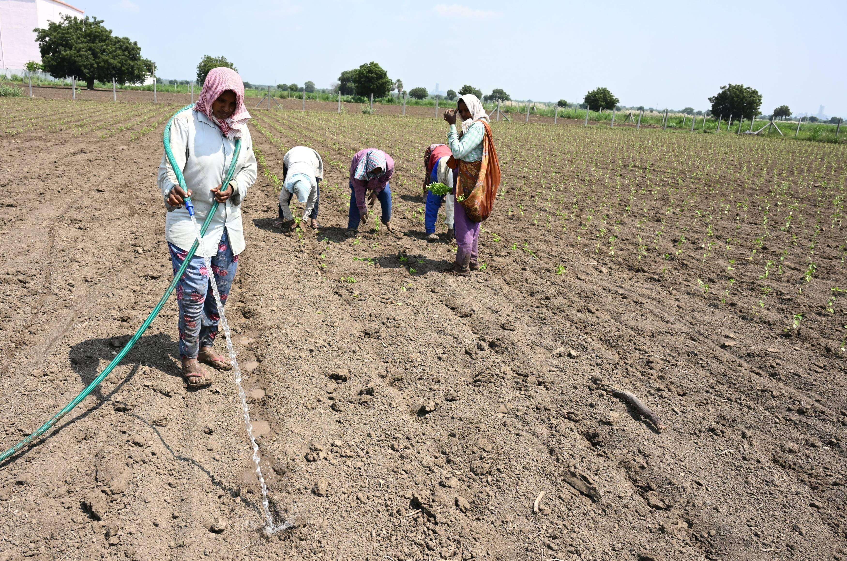
The Maharashtra government has added 40 talukas to its drought-affected list, taking the total from 265 to 305 out of 358 talukas, or about 85% of the state’s talukas.
- Chief Minister Devendra Fadnavis announced ₹5,000 in initial assistance to be transferred to farmers’ bank accounts before Diwali.
- All 12 standard state drought-relief concessions have been extended to the affected talukas.
- A supplementary Government Resolution (GR) adds the newly assessed areas to the declaration.
- The ₹5,000 is announced immediate advance assistance pending wider assessment and further aid; the announcement is not confirmation that every payment has been completed.
Scale of the Crisis
- Maharashtra recorded a reported 18.8% rainfall deficit from June to mid-September 2026.
- Affected areas include Marathwada, Vidarbha and parts of northern Maharashtra.
- The reported distribution includes:
- 74 talukas in Chhatrapati Sambhajinagar division.
- 16 talukas in Yavatmal district.
- 15 talukas in Jalgaon district.
- Crops under stress include soybean, cotton and maize, along with horticultural crops such as oranges, grapes, pomegranates and bananas.
A taluka is an administrative subdivision. The 85% figure describes the share of talukas included in the declaration, rather than the percentage of state land area or population affected.
Relief Measures
Financial and Educational Support
- Direct assistance: ₹5,000 announced for transfer to farmers’ bank accounts before Diwali as urgent support.
- Agricultural credit: Crop-loan restructuring and directions against coercive recovery by cooperative banks and credit societies; the state is seeking a similar approach from private lenders.
- Other concessions: Land-revenue relief, agricultural electricity-bill concessions and fee exemptions for farmers’ children.
- Examination fees: Colleges have been directed not to charge students from drought-affected talukas and to refund fees already collected.
Drinking Water and Fodder
- Water tankers: Early deployment in water-scarce areas, with GPS tracking.
- Supply protection: Nearly 16,000 unauthorised water connections were reported disconnected to protect drinking-water supplies.
- Fodder: Reported reserves range from 90 days to seven months, depending on the region.
- The government has assured procurement support for fodder harvested in suitable areas.
These measures address different effects of drought: reduced farm income, repayment stress, drinking-water scarcity and pressure on livestock feed.
How is Drought Assessed?
India’s Manual for Drought Management, revised in 2016 and updated in 2020, provides a framework for scientific assessment and response.
- Rainfall and dry spells: Identify potential stress and areas needing closer assessment.
- Agriculture: Examine sowing progress and crop conditions.
- Soil moisture and vegetation: Indicate whether plants have sufficient water and whether vegetation is under stress.
- Hydrology: Assess surface-water and groundwater conditions.
- Field verification: Checks observed agricultural impacts before a final determination.
Rainfall shortage is an important indicator, but a drought declaration considers its effects on crops and water availability. Statewide rainfall averages can also conceal severe local shortages.
Additional Info
Different Forms of Drought
| Type | Main feature |
|---|---|
| Meteorological | Rainfall shortage relative to the area’s normal conditions |
| Agricultural | Insufficient soil moisture for crop needs |
| Hydrological | Reduced availability in rivers, reservoirs and groundwater |
IMD Rainfall Categories
- Deficient: Rainfall departure of −20% to −59% from the long-period average.
- Large deficient: −60% or lower.
These categories describe rainfall departures for a specified area and period. They are distinct from the broader administrative assessment used to declare drought and activate relief.
Sources
Kerala Launches Statewide Ecosystem Red List Assessment

What’s the News?
The Kerala State Biodiversity Board (KSBB) has initiated a Red List Assessment of Ecosystems (RLE) covering all 14 districts, described in the reports as India’s first statewide exercise of its kind.
- The assessment uses the International Union for Conservation of Nature (IUCN) framework to examine ecosystem-collapse risk.
- It extends from high-altitude habitats in the Western Ghats to rivers, wetlands and coastal ecosystems.
- The aim is to support conservation, ecological restoration and climate adaptation with evidence about ecosystem condition and threats.
Institutions and Planned Outputs
KSBB funds the work, implemented jointly by:
- Kerala Forest Research Institute (KFRI).
- The Centre for Ecology, Taxonomy, Conservation and Climate Change at MES Asmabi College.
The leading researchers are Dr. Amitha Bachan K.H. and Dr. Deepu Sivadas. KSBB’s project records identify their respective ecosystem-assessment work at MES Asmabi College and KFRI.
| Planned output | Intended use |
|---|---|
| Ecosystem Risk Register | Records assessed ecosystems and their risk status |
| Ecosystem Typology Atlas | Classifies and maps ecosystem types |
| Ecorestoration priority maps | Identifies areas requiring restoration attention |
The findings are intended for integration with state planning portals and use by Biodiversity Management Committees (BMCs) and panchayats. These are planned products; launching the project does not mean all ecosystems have already received final risk classifications.
Ecosystem Risk Versus Species Risk
- The IUCN Red List of Threatened Species assesses the risk that an individual species will become extinct.
- The Red List of Ecosystems examines whether an ecosystem may lose its defining characteristics and ecological functions.
- Collapse means a transformation in the ecosystem’s characteristic composition, structure or processes; it need not mean that every organism disappears.
For example, a wetland can deteriorate through changes in its water regime even if its mapped boundary remains. Assessing ecosystem functions therefore complements assessments of the species living there.
Five Assessment Criteria
| Criterion | What it examines |
|---|---|
| A | Loss of geographical extent |
| B | Risk associated with a restricted distribution |
| C | Deterioration of the physical environment |
| D | Damage to biological processes and interactions |
| E | Modelled probability of ecosystem collapse |
The framework combines spatial evidence with changes in environmental and biological conditions. Fragmentation, altered river flows and degradation can be relevant even where some habitat remains.
Eight Categories
- Collapsed (CO).
- Threatened categories:
- Critically Endangered (CR).
- Endangered (EN).
- Vulnerable (VU).
- Near Threatened (NT).
- Least Concern (LC).
- Data Deficient (DD).
- Not Evaluated (NE).
Data Deficient indicates insufficient evidence for classification; it should not be interpreted as proof of low risk.
Kerala’s Habitats and Pressures
- Riparian evergreen forests: Forests along rivers and streams, dependent on river flow and surrounding conditions.
- Shola-grassland mosaics: High-altitude landscapes containing forest patches and grasslands.
- Myristica swamps: Freshwater swamp forests associated with the Western Ghats.
- Coastal mangroves: Habitats influenced by tidal and estuarine conditions.
Relevant pressures include dam construction and altered hydrology, plantations, fragmentation, urban expansion and climate extremes.
An earlier 2022 study of southern Western Ghats riparian evergreen forests reported 83% loss over the preceding century and assessed the ecosystem as Critically Endangered. Its model projected potential collapse over 20–40 years under the assessed degradation conditions. This is earlier research illustrating the need for assessment, not a new result produced by the statewide project.
Why the Assessment Matters
- Provides a common scientific basis for comparing ecosystem risks.
- Helps prioritise limited restoration resources.
- Supports land-use decisions that consider ecosystem functions as well as habitat boundaries.
- Gives local institutions evidence for conservation and subsequent monitoring.
The statewide initiative builds on earlier ecosystem studies and complements species protection through a broader landscape perspective.
Sources
India–France TRISHNA Mission Targets a 2027 Launch
What’s the News?
ISRO and France’s space agency CNES are developing TRISHNA, an Earth-observation mission designed to measure surface temperature frequently and at high spatial resolution.
- CNES’s current main project page lists a planned launch in 2027 and describes the mission as in development.
- It aims to support water-resource management, agriculture, climate research and urban-heat monitoring.
- The planned launcher is India’s Polar Satellite Launch Vehicle (PSLV) from Sriharikota.
- The launch year remains a planning target, rather than a completed launch or a confirmed launch date.
Mission and Observation Plan
TRISHNA stands for Thermal Infra-Red Imaging Satellite for High-resolution Natural Resource Assessment.
| Parameter | Planned specification |
|---|---|
| Partner agencies | Indian Space Research Organisation and Centre National d’Études Spatiales |
| Orbit | Sun-synchronous, approximately 761 km above Earth |
| Local crossing time | About 12:30 p.m. at the descending node |
| Revisit at the equator | About three days between observations of the same point |
| Camera resolution | About 57–90 metres, varying across the image swath |
| Standard product resolution | About 60 metres |
| Designed life | Five years |
- Sun-synchronous orbit: Maintains approximately the same local solar time for comparable passes, helping observations taken on different days remain comparable.
- Spatial resolution: Describes how finely the surface can be distinguished.
- Revisit interval: Describes how often the satellite can observe a location; it is distinct from spatial resolution.
ISRO’s mission description specifies 57-metre observations for land and coastal areas and 1-km observations for oceanic and polar regions. CNES separately distinguishes camera sampling from the 60-metre delivered product.
Two Complementary Instruments
| Payload | Provider | Main measurements |
|---|---|---|
| Thermal Infra-Red (TIR) | CNES | Four long-wave infrared channels for surface temperature and emissivity |
| Visible–Near Infra-Red–Short Wave Infra-Red (VNIR–SWIR) | ISRO | Seven spectral bands for surface reflectance and biophysical variables |
- Thermal data show emitted heat and help estimate surface temperature.
- Optical data provide complementary information about vegetation and surface characteristics.
- Combining them supports estimates of surface energy balance and heat fluxes.
- Emissivity describes how effectively a surface emits thermal radiation, which is relevant when converting observed radiation into temperature estimates.
Why Monitor Evapotranspiration?
Evapotranspiration combines:
- Evaporation: Water leaving soil and water surfaces as vapour.
- Transpiration: Water released by plants.
It connects the water cycle with the surface energy budget. Frequent thermal observations can help researchers estimate plant water stress and water use, informing irrigation decisions and drought monitoring.
Main Applications
- Agriculture: Assess irrigation water use, crop-water productivity and water-saving opportunities.
- Water bodies: Study water quality and dynamics in lakes, rivers, estuaries and coastal waters.
- Cities: Map urban heat islands and support analysis of heat-stressed areas.
- Snow and glaciers: Monitor snowmelt runoff and glacier dynamics for hydrological studies.
- Solid Earth: Identify thermal anomalies associated with volcanic activity, geothermal resources and subsurface fires.
- Atmosphere: Provide information relevant to aerosols, water vapour and cloud cover.
Additional Info
India–France space cooperation includes earlier joint missions:
- Megha-Tropiques (2011): Studied the tropical water cycle and energy exchanges.
- SARAL (2013): Supported oceanographic studies using altimetry and related measurements.
TRISHNA extends this cooperation to frequent, detailed observations of Earth’s surface temperature and associated water and energy processes.
Sources
Oman Becomes India’s Largest LNG Supplier in September 2026

What’s the News?
Oman overtook the United States as India’s largest liquefied natural gas (LNG) supplier in September 2026, according to reported vessel-tracking data from Kpler.
- Oman supplied approximately 585,000 tonnes, up 11.6% from August, accounting for about 27% of monthly imports.
- Nigeria ranked second, while the US moved to third.
- Qatar, historically a major supplier, ranked sixth, with about 94,000 tonnes, or roughly 4% of the monthly total.
- These are monthly supplier rankings.
September Supplier Mix
| Rank | Supplier | Approximate volume |
|---|---|---|
| 1 | Oman | 585,000 tonnes |
| 2 | Nigeria | 351,000 tonnes |
| 3 | United States | 0.34 million tonnes, rounded |
| 4 | United Arab Emirates | 311,000 tonnes |
| 5 | Angola | 205,000 tonnes |
| 6 | Qatar | 94,000 tonnes |
- Nigeria’s volume fell about 35% month-on-month, despite its second-place ranking.
- US supplies fell sharply as European buyers competed for American cargoes.
- Reported Kpler-based figures put India’s total at 2.17 million tonnes, down about 14% from 2.5 million tonnes in August.
Why Does Geography Matter?
The Strait of Hormuz connects the Persian Gulf with the Gulf of Oman and Arabian Sea. It is a critical passage for LNG exports from producers inside the Gulf, particularly Qatar.
- West Asian conflict and shipping disruptions have affected supplies using the strait.
- Ras Laffan Industrial City, Qatar’s major LNG hub, has also faced conflict-related disruption.
- Oman’s LNG facilities at Qalhat, near Sur, lie outside the Strait of Hormuz. Their cargoes can sail towards India without passing through that chokepoint.
- Supplies from other sources, including Nigeria and Angola, provide alternatives to Gulf-dependent routes.
Diversifying suppliers can reduce concentration on a disrupted route, although buyers still face international prices, freight costs and competition for available cargoes.
Implications for India
- Supply continuity: A wider supplier pool helps importers replace disrupted cargoes.
- Cost exposure: Securing replacement cargoes on the spot market can raise costs when global supply is tight.
- Industrial demand: Gas is used in fertiliser production, power generation, city gas distribution, ceramics and other industries.
- Infrastructure: Imported LNG requires receiving terminals, regasification facilities and connections to domestic gas pipelines.
What is LNG?
- Liquefied natural gas is natural gas cooled to about −162°C.
- Liquefaction reduces its volume to roughly 1/600 of its gaseous volume, making shipment by sea practical.
- It is carried in specially insulated LNG tankers.
- Regasification converts the liquid back into gas at the receiving terminal before pipeline distribution.
LNG differs from LPG, which consists mainly of propane and butane. They have different compositions and storage requirements.
Odisha Context: Dhamra LNG Terminal
- Location: Dhamra Port, Bhadrak district, Odisha.
- Regasification capacity: 5 million tonnes per annum.
- First cargo: 2023.
- The terminal is associated with the Adani–TotalEnergies joint venture and strengthens LNG-receiving infrastructure on India’s east coast.
Sources
Oscar Whitfield Wins Young Wildlife Photographer of the Year 2026
What’s the News?
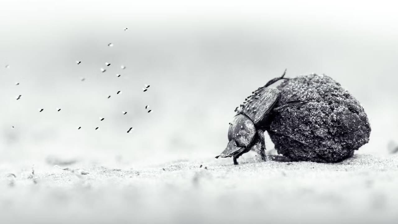
Oscar Whitfield, a British photographer living in Zimbabwe, has won Young Wildlife Photographer of the Year 2026 for his black-and-white photograph “Labour of Love”.
- The image shows a dung beetle pushing a dung ball through sand in Zambezi National Park, Zimbabwe.
- Whitfield was 14 when he took the photograph and won in the 11–14 Years category, as well as receiving the young grand title.
- The competition is organised by the Natural History Museum, London.
The Winning Image
Whitfield noticed the beetle during a family game drive. The insect was pushing its ball uphill, with flying insects following behind it.
- He lay flat on the dusty ground to photograph the beetle at eye level.
- A fast shutter speed and high light sensitivity helped capture the small, moving subject.
- The close perspective brings attention to an interaction easily missed when viewing larger animals from a vehicle.
The photograph places a small invertebrate at the centre of a wildlife story, illustrating the importance of organisms that often receive less attention than large mammals.
Competition and Other Winners
| Feature | 2026 details |
|---|---|
| Edition | 62nd |
| Entries | A record 65,403 |
| Geographic participation | 121 countries and territories |
| Young age categories | 10 Years and Under; 11–14 Years; 15–17 Years |
An international jury assesses entries for originality, technical excellence, creativity and ethical practice.
- Adult grand title: Federico Veronesi of Italy, for “The Aftermath”, showing an elephant carrying a dead calf in Namibia’s Huab River Valley.
- Indian category winner: Sitaram Raul won Behaviour: Invertebrates.
- Historic distinction: For the first time in the competition’s 62-year history, both the adult and young overall winners were black-and-white photographs.
Sources
October 2026
Archive
October 2026
- 27 October 2026
- 26 October 2026
- 24 October 2026
- 23 October 2026
- 22 October 2026
- 21 October 2026
- 20 October 2026
- 19 October 2026
- 17 October 2026
- 16 October 2026
- 15 October 2026
- 14 October 2026
- 13 October 2026
- 12 October 2026
- 10 October 2026
- 09 October 2026
- 08 October 2026
- 07 October 2026
- 06 October 2026
- 05 October 2026
- 03 October 2026
- 02 October 2026
- 01 October 2026
September 2026
- 30 September 2026
- 29 September 2026
- 28 September 2026
- 26 September 2026
- 25 September 2026
- 24 September 2026
- 23 September 2026
- 22 September 2026
- 21 September 2026
- 19 September 2026
- 18 September 2026
- 17 September 2026
- 16 September 2026
- 15 September 2026
- 12 September 2026
- 11 September 2026
- 10 September 2026
- 09 September 2026
- 08 September 2026
- 07 September 2026
- 05 September 2026
- 04 September 2026
- 03 September 2026
- 02 September 2026
- 01 September 2026
August 2026
- 31 August 2026
- 29 August 2026
- 27 August 2026
- 26 August 2026
- 25 August 2026
- 24 August 2026
- 22 August 2026
- 21 August 2026
- 20 August 2026
- 19 August 2026
- 18 August 2026
- 17 August 2026
- 14 August 2026
- 13 August 2026
- 12 August 2026
- 11 August 2026
- 10 August 2026
- 08 August 2026
- 07 August 2026
- 06 August 2026
- 05 August 2026
- 04 August 2026
- 03 August 2026
- 01 August 2026
July 2026
- 31 July 2026
- 30 July 2026
- 29 July 2026
- 28 July 2026
- 27 July 2026
- 25 July 2026
- 23 July 2026
- 22 July 2026
- 21 July 2026
- 20 July 2026
- 18 July 2026
- 17 July 2026
- 15 July 2026
- 14 July 2026
- 13 July 2026
- 11 July 2026
- 10 July 2026
- 09 July 2026
- 08 July 2026
- 07 July 2026
- 06 July 2026
- 04 July 2026
- 03 July 2026
- 02 July 2026
- 01 July 2026
June 2026
May 2026
April 2026
March 2026
- 31 March 2026
- 30 March 2026
- 28 March 2026
- 27 March 2026
- 26 March 2026
- 25 March 2026
- 24 March 2026
- 23 March 2026
- 21 March 2026
- 20 March 2026
- 19 March 2026
- 18 March 2026
- 17 March 2026
- 16 March 2026
- 14 March 2026
- 13 March 2026
- 12 March 2026
- 11 March 2026
- 10 March 2026
- 09 March 2026
- 07 March 2026
- 06 March 2026
- 05 March 2026
- 03 March 2026
- 02 March 2026
February 2026
- 28 February 2026
- 27 February 2026
- 26 February 2026
- 25 February 2026
- 24 February 2026
- 23 February 2026
- 21 February 2026
- 20 February 2026
- 19 February 2026
- 18 February 2026
- 17 February 2026
- 16 February 2026
- 13 February 2026
- 12 February 2026
- 11 February 2026
- 10 February 2026
- 09 February 2026
- 07 February 2026
- 06 February 2026
- 05 February 2026
- 04 February 2026
- 03 February 2026
- 02 February 2026
January 2026
- 31 January 2026
- 30 January 2026
- 29 January 2026
- 28 January 2026
- 27 January 2026
- 26 January 2026
- 24 January 2026
- 23 January 2026
- 22 January 2026
- 21 January 2026
- 20 January 2026
- 19 January 2026
- 16 January 2026
- 15 January 2026
- 14 January 2026
- 13 January 2026
- 12 January 2026
- 10 January 2026
- 09 January 2026
- 08 January 2026
- 07 January 2026
- 06 January 2026
- 05 January 2026
- 03 January 2026
- 02 January 2026
- 01 January 2026
December 2025
- 31 December 2025
- 30 December 2025
- 29 December 2025
- 27 December 2025
- 26 December 2025
- 24 December 2025
- 23 December 2025
- 22 December 2025
- 20 December 2025
- 19 December 2025
- 18 December 2025
- 17 December 2025
- 16 December 2025
- 15 December 2025
- 13 December 2025
- 12 December 2025
- 11 December 2025
- 10 December 2025
- 09 December 2025
- 08 December 2025
- 05 December 2025
- 04 December 2025
- 03 December 2025
- 02 December 2025
November 2025
- 29 November 2025
- 28 November 2025
- 27 November 2025
- 26 November 2025
- 25 November 2025
- 24 November 2025
- 22 November 2025
- 21 November 2025
- 20 November 2025
- 19 November 2025
- 18 November 2025
- 17 November 2025
- 15 November 2025
- 14 November 2025
- 13 November 2025
- 12 November 2025
- 11 November 2025
- 10 November 2025
- 08 November 2025
- 07 November 2025
- 06 November 2025
- 05 November 2025
- 04 November 2025
- 03 November 2025
- 01 November 2025
October 2025
- 31 October 2025
- 30 October 2025
- 29 October 2025
- 28 October 2025
- 27 October 2025
- 25 October 2025
- 24 October 2025
- 23 October 2025
- 22 October 2025
- 21 October 2025
- 20 October 2025
- 18 October 2025
- 17 October 2025
- 16 October 2025
- 15 October 2025
- 14 October 2025
- 13 October 2025
- 11 October 2025
- 10 October 2025
- 09 October 2025
- 08 October 2025
- 07 October 2025
- 06 October 2025
- 04 October 2025
- 03 October 2025
- 02 October 2025
- 01 October 2025
September 2025
- 30 September 2025
- 29 September 2025
- 27 September 2025
- 26 September 2025
- 25 September 2025
- 24 September 2025
- 23 September 2025
- 22 September 2025
- 20 September 2025
- 19 September 2025
- 18 September 2025
- 17 September 2025
- 16 September 2025
- 15 September 2025
- 13 September 2025
- 12 September 2025
- 11 September 2025
- 10 September 2025
- 09 September 2025
- 08 September 2025
- 06 September 2025
- 05 September 2025
- 04 September 2025
- 03 September 2025
- 02 September 2025
- 01 September 2025
August 2025
- 30 August 2025
- 29 August 2025
- 28 August 2025
- 27 August 2025
- 26 August 2025
- 25 August 2025
- 23 August 2025
- 22 August 2025
- 21 August 2025
- 20 August 2025
- 19 August 2025
- 18 August 2025
- 16 August 2025
- 14 August 2025
- 13 August 2025
- 12 August 2025
- 11 August 2025
- 08 August 2025
- 07 August 2025
- 06 August 2025
- 05 August 2025
- 04 August 2025
- 02 August 2025
- 01 August 2025
July 2025
- 31 July 2025
- 30 July 2025
- 29 July 2025
- 28 July 2025
- 26 July 2025
- 25 July 2025
- 24 July 2025
- 23 July 2025
- 22 July 2025
- 21 July 2025
- 19 July 2025
- 18 July 2025
- 17 July 2025
- 16 July 2025
- 15 July 2025
- 12 July 2025
- 11 July 2025
- 10 July 2025
- 09 July 2025
- 07 July 2025
- 05 July 2025
- 04 July 2025
- 03 July 2025
- 02 July 2025
- 01 July 2025
June 2025
- 30 June 2025
- 28 June 2025
- 27 June 2025
- 26 June 2025
- 25 June 2025
- 24 June 2025
- 23 June 2025
- 21 June 2025
- 20 June 2025
- 19 June 2025
- 18 June 2025
- 17 June 2025
- 16 June 2025
- 14 June 2025
- 13 June 2025
- 12 June 2025
- 11 June 2025
- 10 June 2025
- 09 June 2025
- 07 June 2025
- 06 June 2025
- 05 June 2025
- 04 June 2025
- 03 June 2025
- 02 June 2025
May 2025
April 2025
- 30 April 2025
- 29 April 2025
- 28 April 2025
- 26 April 2025
- 25 April 2025
- 24 April 2025
- 23 April 2025
- 22 April 2025
- 21 April 2025
- 19 April 2025
- 18 April 2025
- 17 April 2025
- 16 April 2025
- 15 April 2025
- 14 April 2025
- 12 April 2025
- 11 April 2025
- 10 April 2025
- 09 April 2025
- 08 April 2025
- 07 April 2025
- 05 April 2025
- 04 April 2025
- 03 April 2025
- 02 April 2025
- 01 April 2025
March 2025
- 31 March 2025
- 29 March 2025
- 28 March 2025
- 27 March 2025
- 26 March 2025
- 25 March 2025
- 24 March 2025
- 22 March 2025
- 21 March 2025
- 20 March 2025
- 19 March 2025
- 18 March 2025
- 17 March 2025
- 15 March 2025
- 13 March 2025
- 12 March 2025
- 11 March 2025
- 10 March 2025
- 08 March 2025
- 07 March 2025
- 06 March 2025
- 05 March 2025
- 04 March 2025
- 03 March 2025
- 01 March 2025
February 2025
- 28 February 2025
- 27 February 2025
- 26 February 2025
- 25 February 2025
- 24 February 2025
- 22 February 2025
- 21 February 2025
- 20 February 2025
- 19 February 2025
- 18 February 2025
- 17 February 2025
- 15 February 2025
- 14 February 2025
- 13 February 2025
- 12 February 2025
- 11 February 2025
- 10 February 2025
- 08 February 2025
- 07 February 2025
- 06 February 2025
- 05 February 2025
- 04 February 2025
- 03 February 2025
- 01 February 2025
January 2025
- 31 January 2025
- 30 January 2025
- 29 January 2025
- 28 January 2025
- 27 January 2025
- 25 January 2025
- 24 January 2025
- 23 January 2025
- 22 January 2025
- 21 January 2025
- 20 January 2025
- 18 January 2025
- 17 January 2025
- 16 January 2025
- 15 January 2025
- 14 January 2025
- 13 January 2025
- 11 January 2025
- 10 January 2025
- 09 January 2025
- 08 January 2025
- 07 January 2025
- 06 January 2025
- 04 January 2025
- 03 January 2025
- 02 January 2025
- 01 January 2025